


![]()
Leo and I decided to get in a backpacking trip close to home. Since Leo had never been up to Maggie's Half Acre before we decided to make that our destination. Maggie's Half Acre lies just under Rose Peak in the Ohlone Wilderness. You must reserve one of the three spots ahead of time and the fee over the phone was $17 for both of us for one night (not inculding the Ohlone Trail Permit, $2 each). We did a Sunday Monday trip (with questionable weather forecast) and had the trail to ourselves for the most part. (There were some scouts coming out and a survey class headed in but no one else camped out there). The trailhead we took off from was Sunol Regional Wilderness. I have done this trip a few times so check out the trips section for additional descriptions and for the trip all the way to Del Valle. Call 510-636-1684 for reservations or for general info the ranger at Sunol is 510-862-2244. See the maps below for a look at the trail. You start at around 400 feet and camp is 3600 feet so make sure you are ready for significant up. There are no campsites to stop at between the Backpacking Area in Sunol and the horse camp just before Maggie's Half Acre so you have to be ready to make it all the way. It is around 8 miles from the trailhead to Maggie's Half Acre the route we took.
 Here
is Leo before we took off from the trailhead. We decided to take Leo's
jeep to keep our gear covered on the way there and on the way back.
We really needed it on the way back as it just poured when we stowed
our gear after hiking out. You need to have a permit to hike past the
Backpackers area and can get one when you make your reservation by phone,
or wait until the day of and get one from the ranger. They cost 2 dollars
now in person and are valid for 1 year. Your permit is also your trail
map so make sure to get one for both of those reasons. You are required
to stay on the trail as there are private and watershed lands surrounding
the trail.
Here
is Leo before we took off from the trailhead. We decided to take Leo's
jeep to keep our gear covered on the way there and on the way back.
We really needed it on the way back as it just poured when we stowed
our gear after hiking out. You need to have a permit to hike past the
Backpackers area and can get one when you make your reservation by phone,
or wait until the day of and get one from the ranger. They cost 2 dollars
now in person and are valid for 1 year. Your permit is also your trail
map so make sure to get one for both of those reasons. You are required
to stay on the trail as there are private and watershed lands surrounding
the trail.
 With
all of this year's rain it was no surprise to see the river running
so high. We chatted with a guy on the way in that was camped near the
river in the family camping area in Sunol and he told us the Ranger
warned them to keep an eye on the river because if they let water out
of the damn things could become very wet very fast for them. He was
with a group of Fresno students surveying the area.
With
all of this year's rain it was no surprise to see the river running
so high. We chatted with a guy on the way in that was camped near the
river in the family camping area in Sunol and he told us the Ranger
warned them to keep an eye on the river because if they let water out
of the damn things could become very wet very fast for them. He was
with a group of Fresno students surveying the area.
 It
is a little hazy in this shot but you can see how green everything is.
This is one of the many small streams that flow into the river. It seems
water is coming out of the hills anywhere it can this year. The trail
was surprisingly good though. I had expected it to be much more muddier
than it ended up being.
It
is a little hazy in this shot but you can see how green everything is.
This is one of the many small streams that flow into the river. It seems
water is coming out of the hills anywhere it can this year. The trail
was surprisingly good though. I had expected it to be much more muddier
than it ended up being.
 So
we followed the road to the turn off for the backpacker's area and headed
up the hill. The road travels along the river the whole way in to this
point. This shot was taken of the sign once you pass through the first
of many cattle gates on the way to some backpacking camps. There are
Mountain Lions in this area. I have seen them (luckily from a distance).
So
we followed the road to the turn off for the backpacker's area and headed
up the hill. The road travels along the river the whole way in to this
point. This shot was taken of the sign once you pass through the first
of many cattle gates on the way to some backpacking camps. There are
Mountain Lions in this area. I have seen them (luckily from a distance).
 This
is the view on the way to the Backpacking area. You can tell that you
have gained some elevation at this point. It was overcast the whole
way in with rain predicted for that late afternoon and the next morning.
There was a slight breeze and we knew it was only a matter of time before
we started getting wet.
This
is the view on the way to the Backpacking area. You can tell that you
have gained some elevation at this point. It was overcast the whole
way in with rain predicted for that late afternoon and the next morning.
There was a slight breeze and we knew it was only a matter of time before
we started getting wet.
 This
is Hawks Rest with its glorious table. It has been in this state for
a number of years. I remember camping at this site with two tents and
walking around it I just can't see how that is possible anymore. Could
this site have shrunk? It does have a nice view and someone put in a
nice bench with metal plate for your stove. This site is ON the trail
though so be prepared to chat with everyone and also everyone that needs
water will be walking by since this is the site that is closest to the
water as well.
This
is Hawks Rest with its glorious table. It has been in this state for
a number of years. I remember camping at this site with two tents and
walking around it I just can't see how that is possible anymore. Could
this site have shrunk? It does have a nice view and someone put in a
nice bench with metal plate for your stove. This site is ON the trail
though so be prepared to chat with everyone and also everyone that needs
water will be walking by since this is the site that is closest to the
water as well.
 The
trail continues up and to the left after Hawks Rest. There is one more
site Eagles Aerie (sp) that is on the right. This is the site that I
would choose to camp at if this is as far as you want to hike. Near
enough the water but off the trail and has great views. This picture
is of the trail after you get up and over the ridge above the backpacking
area. Most of this trail is exposed like this so if it is sunny bring
a hat and sunscreen.
The
trail continues up and to the left after Hawks Rest. There is one more
site Eagles Aerie (sp) that is on the right. This is the site that I
would choose to camp at if this is as far as you want to hike. Near
enough the water but off the trail and has great views. This picture
is of the trail after you get up and over the ridge above the backpacking
area. Most of this trail is exposed like this so if it is sunny bring
a hat and sunscreen.
 Here
is a shot of some of the rocks you see in the area. There are quite
a few of these formations along the trail and in the distance.
Here
is a shot of some of the rocks you see in the area. There are quite
a few of these formations along the trail and in the distance.
 There
are quite a few Oaks in the area and this is one that just screamed
to be photographed. It looks even better in person though.
There
are quite a few Oaks in the area and this is one that just screamed
to be photographed. It looks even better in person though.
 The
trail is well marked and most of the trail posts are marked with a number
so you can tell (rather quickly) where you are on the trail. There are
not too many areas that you can get lost on this trip as long as you
keep your eyes open for the trail posts. I prefer not to look at the
map on the way in so I don't know how much uphill I have left.
The
trail is well marked and most of the trail posts are marked with a number
so you can tell (rather quickly) where you are on the trail. There are
not too many areas that you can get lost on this trip as long as you
keep your eyes open for the trail posts. I prefer not to look at the
map on the way in so I don't know how much uphill I have left.
 As
I mentioned earlier there are many cattle gates and this is another
one. I can't imagine what it takes to put up some of the fencing that
is up here. I have hiked quite a bit and I have only seen a fence being
put up once. It didn't look like a fun part of the cattle ranching business
to me.
As
I mentioned earlier there are many cattle gates and this is another
one. I can't imagine what it takes to put up some of the fencing that
is up here. I have hiked quite a bit and I have only seen a fence being
put up once. It didn't look like a fun part of the cattle ranching business
to me.
 Leo
decided to drink all of his water on the way in so we decided to filter
some water at one of the many small streams crossing the trail. I use
the PUR Hiker (which now is the Katydin Hiker). It has served me well
but pumping it is taking more force than usual now so I am going to
have to really take it apart and see why.
Leo
decided to drink all of his water on the way in so we decided to filter
some water at one of the many small streams crossing the trail. I use
the PUR Hiker (which now is the Katydin Hiker). It has served me well
but pumping it is taking more force than usual now so I am going to
have to really take it apart and see why.
 The
weather was starting to change on us and I wasn't sure if we would end
up getting wet before we set up camp.
The
weather was starting to change on us and I wasn't sure if we would end
up getting wet before we set up camp.
 This
shot is of a stream you cross after going down a steep section ad then
back up the other side. There is a good uphill section after this but
Maggie's' Half Acre isn't too much further.
This
shot is of a stream you cross after going down a steep section ad then
back up the other side. There is a good uphill section after this but
Maggie's' Half Acre isn't too much further.
 You
can start seeing Mount Diablo now in the distance. This is the only
real shot I got of it. The next day was way too foggy/overcast. Look
at some of my other trips to this area for better shots.
You
can start seeing Mount Diablo now in the distance. This is the only
real shot I got of it. The next day was way too foggy/overcast. Look
at some of my other trips to this area for better shots.
 This
is Leo hiking out ahead of me. The sky was darkening up now. This is
when you are "really" close now. At least that is what I was
telling my calves at this point.
This
is Leo hiking out ahead of me. The sky was darkening up now. This is
when you are "really" close now. At least that is what I was
telling my calves at this point.
 So
we set up camp in my new tent (REI Half dome 2 HC). Yes it started raining
shortly after we filtered some water and ate a late lunch so we basically
set up camp in the tent. The tent was awesome though. With the 2 vestibules
we were able to stow our gear out of the elements and go in and out
of the tent on our own terms. I was able to cook while hanging myself
out of the tent without too much trouble. I do have long arms and I
would say that helped but I think you could set up a stove a safe distance
away and not have to exit the tent too much to reach it. This shot of
the tent is actually the next morning when we were surrounded by "misty
fog".
So
we set up camp in my new tent (REI Half dome 2 HC). Yes it started raining
shortly after we filtered some water and ate a late lunch so we basically
set up camp in the tent. The tent was awesome though. With the 2 vestibules
we were able to stow our gear out of the elements and go in and out
of the tent on our own terms. I was able to cook while hanging myself
out of the tent without too much trouble. I do have long arms and I
would say that helped but I think you could set up a stove a safe distance
away and not have to exit the tent too much to reach it. This shot of
the tent is actually the next morning when we were surrounded by "misty
fog".
 Here is some more of the scenery that morning. We were just happy the
rain let up though.
Here is some more of the scenery that morning. We were just happy the
rain let up though.
 We
headed back to the jeep the same way we came in. There is plenty of
downhill going back so take your time and don't wear out your knees
too early.
We
headed back to the jeep the same way we came in. There is plenty of
downhill going back so take your time and don't wear out your knees
too early.
We didn't see too many people on the way out (being Monday) and we thought
we would be getting rained on at any time. We had it mist on us a little
and then slight drizzle but nothing significant. Here is a gigantic
slug we found crossing the trail. He had a friend a little later on
the trail. I didn't take too many pictures on the way out due to the
misty weather conditions. We made it back to the Jeep and it just poured
on us so we quickly threw our gear into the jeep and headed out. It
was a great trip and I am sure we will be back again.
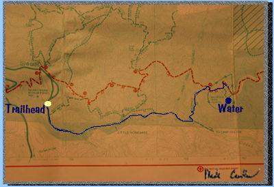 This
map is from the trailhead at the parking area and the blue line is the
route we took. Were we intersect with the redline and off the map to
the right is where the next map starts.
This
map is from the trailhead at the parking area and the blue line is the
route we took. Were we intersect with the redline and off the map to
the right is where the next map starts.
 Here
is the rest of the trail we took. The res line is the Ohlone trail.
The yellow mark is our campsite (approximately).
Here
is the rest of the trail we took. The res line is the Ohlone trail.
The yellow mark is our campsite (approximately).