![]()
We decided to
do a local trip to see what kind of backpacking shape we were all in.
Leo, Dan, Jenn, Zakk and I went on this, very green, Ohlone WIlderness
Trail trip to Eagle Springs backpacking camp. We were supposed to have
Eric as well, sadly he was unable to make it this time (we missed you
Eric). We picked this spot because it was local and for a local trip
it is pretty sweet. Eagle Springs Backpack Camp can be reached  using the Ohlone Wilderness trail from either Sunol Regional Wilderness
or Mission Peak Regional Preserve. Heading in from the Mission Peak
side makes for a significantly shorter hike, but much steeper. You would
head in from the Stanford Ave staging area if you pack in from this
side (I am told there is no overnight parking at the staging area).
I have yet to hike this short section of trail but will someday. We
decided to use our usual route, the Sunol side. If you want to see this
trip in fall 2011 click here, spring
2009 click here, 2005 click
here. Park at the equestrian area for the closest parking to the
trailhead. You must call
ahead for reservations as Sunol backpacking is popular. Prices were
$5 a person per night and an $8 reservation fee over the phone. Reservations
can be made by calling 888-327-2757 but for questions about conditions
or recommendations call the local ranger at 925-862-2244. They actually
give you a parking permit now when you reserve online now, so if you
don't find a ranger when you arrive it is no big deal. There are 4 sites
available at Eagle Springs. All four sites have picnic tables and flat
areas for at least a tent or two. Water is available but the recommendation
from rangers is to treat it (many cows out here). There is also a pretty
nice outhouse and trash cans. Site #4 has the largest tree, and the
only real shade. If you are doing this trip in the summer/heat pick
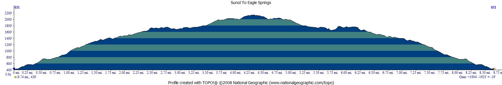
site #4. Hiking in from this side is around 4.3 ish miles and 1700 feet
up. The grade is mild but don't take my word for it, see the map
and profile below. You can do a quick 20 minute day hike from the
backpacking area to the top of Mission Peak. We camped on a Saturday
night and saw a bigger group at the top of the peak. I have gone midweek
and it is much less crowded. There is enough space on the trail up to
the peak that you can spread out. This picture shows the trail on the
way in, everything was nice and green.
using the Ohlone Wilderness trail from either Sunol Regional Wilderness
or Mission Peak Regional Preserve. Heading in from the Mission Peak
side makes for a significantly shorter hike, but much steeper. You would
head in from the Stanford Ave staging area if you pack in from this
side (I am told there is no overnight parking at the staging area).
I have yet to hike this short section of trail but will someday. We
decided to use our usual route, the Sunol side. If you want to see this
trip in fall 2011 click here, spring
2009 click here, 2005 click
here. Park at the equestrian area for the closest parking to the
trailhead. You must call
ahead for reservations as Sunol backpacking is popular. Prices were
$5 a person per night and an $8 reservation fee over the phone. Reservations
can be made by calling 888-327-2757 but for questions about conditions
or recommendations call the local ranger at 925-862-2244. They actually
give you a parking permit now when you reserve online now, so if you
don't find a ranger when you arrive it is no big deal. There are 4 sites
available at Eagle Springs. All four sites have picnic tables and flat
areas for at least a tent or two. Water is available but the recommendation
from rangers is to treat it (many cows out here). There is also a pretty
nice outhouse and trash cans. Site #4 has the largest tree, and the
only real shade. If you are doing this trip in the summer/heat pick
site #4. Hiking in from this side is around 4.3 ish miles and 1700 feet
up. The grade is mild but don't take my word for it, see the map
and profile below. You can do a quick 20 minute day hike from the
backpacking area to the top of Mission Peak. We camped on a Saturday
night and saw a bigger group at the top of the peak. I have gone midweek
and it is much less crowded. There is enough space on the trail up to
the peak that you can spread out. This picture shows the trail on the
way in, everything was nice and green.
Here I am taking a picture
at the Sunol Regional Wilderness equestrian area parking lot. There
is an outhouse and horse water. So plan ahead and have water with you
for the trip in, unless you drink from troughs. The ranger also says
to treat water at camp. There is water at camp, and we watched people
drink from it all day, untreated. It is probably fine to just drink
it straight unless posted otherwise. I treated or boiled mine, as did
the rest of our group. I didn't want to be the one to prove there was
a reason to treat it! The trail starts past the two people in this shot
(see gate between them and the picnic table). I was hiking alone on
the way in (late start for me, the rest of the group hiked in earlier
in the day). In case you are concerned, I made it to camp just fine
:-)

The cloud cover was an excellent
backdrop for the trees today. I am honestly surprised I didn't walk
into a cow pie on this trip, since I was looking everywhere but down
for most of the hike in. So you start in what seems like the wrong direction
at first, but the trail quickly starts to head the right way. Many portions
of this trail follow fire road, but there is a mix of cover and open
fields that keep it interesting. The views along the way are also great,
so turn around occasionally and take it all in.

Here is a shot looking backwards
on the way in of the Calaveras Road Crossing. You cross the road (on
the left of the picture), then across the grass, then up the hill on
the fire road. Trails are well marked and easy to follow. There are
many cow trails, but those look like cow trails, not the wide Ohlone
trail.

Before I knew it I was at "The Old Homestead", only a small
stone section of it remains. There is a private residence to the right,
so stay left (unless you are the lucky ones that live there, and in
that case please send me an email/invitation to stop by).

The oak trees were amazing. I took many photo taking breaks on the way
in, it gave me a chance to catch my breath on the almost entirely uphill
route.

There are really no reliable water stops on the way in (unless you want
to fight with these guys over their trough). Make sure you have enough
water to get to camp, especailly in warm weather. These cows were "fighting"
in slow motion, slowly pushing each other with their heads, silly cows.

This section of trail passes through San Francisco Water District land
and is marked to stay on the trail.

One of my looking up breaks.
This picture makes me smile for some reason.

After the semi-covered sections
of fire road it really opens up, this section is really warm (and really
brown) in the summer.

This rather deep dry creek
bed was a sharp contrast to the green terrain. It looked like a giant
ground squirrel hole to me, you can see all of the normal size ones
around it. I waited a bit, but never did see the inhabitant to the big
hole... 
This is one of my favorite
pictures of the trip. I used to read water meters and I saw one of these
birds on my route and had a heck of a time trying to figure out what
kind of bird it was. It turns out it was a yellow-billed magpie. I haven't
seen one in 10 years, glad they seem to still be around. This is a male
(on the left) and a female (on the right). They are about the size of
a crow but have a bright blue patch on the wings and on the tail.

This is the back of the
male, this one was chatting it up with the female (hopefully she was
interested, so there are more of these guys around the next time I am
out here). Their yellow bill really makes them stand out.

Here is the much more common ground squirrel out and about. They are
funny to watch scurry about and dive down their holes.

This is a shot of the Eagle Springs campsites before it dips down into
the ravine (shooting into the sun so it looks hazy). The table with
people around it is under "the tree" at site #4. Really only
1 spot for a tent at this site, but space for 2 hammocks (according
to my hammock expert in the group).

Here is a shot looking backwards
from where the trail dips down into the ravine and the Laurel Canyon
Trail junction.

I made it to camp, here is
a shot from site #4. All sites have this same view. You can see Sunol/Pleasanton
Ridge on left and Mount Diablo in the distance. At night you can see
I-680, but can't hear it.

We decided to hike up to
Mission Peak before dinner. Here is Jenn communicating with the cows.
It looks like she is setting up her tripod (only those are really trekking
poles).

Another shot of Mount Diablo
on our way up Mission Peak. We had some clouds blowing in now.

Here we are on Mission Peak
on a Saturday night. Yes, there are a lot of people up on the peak.
We decided to stay closer to "our side" of the peak and watch
the sunset. On a clear day this would be a spectacular view, today it
was good too.

Here is the last glimpse
of the sun that day.

We hung out another 10 minutes
or so, but were motivated to get out of the wind (did I mention it was
really getting windy) and get some dinner back at camp. That night we
were able to have some of the wind blocked by "the tree",
but it was going to be windy all night. Those of us in tents would have
some tent noise to try to sleep through.

My BIg Agnes Scout UL2 performed
well in the wind. I had it guyed out tight and it moved some but never
seemed to be in danger of failing. The main problem with this tent in
the wind is the vent that runs under the eaves. When the wind come through
the vent it inflates the tent some before escaping out the vent on the
other side. I probably should have had my tent face into the wind, but
it wasn't windy when I set it up (and I was too tired to consider flipping
it around at bedtime). Here is the view in the morning from my tent.

We decided to take a quick
group picture after breakfast before heading out.

Here we are leaving the
fence enclosed Eagle Springs campsites. The water is past the signboard
and the bathroom and trash cans are inside on the left.

The good part about all
the up the day before was all the down on the way back. Here is Leo
looking at what lies ahead.

This fence needed its picture
taken.

Here is the last good shot
I took on the way out. We are close to the trailhead at this point.
Another great trip close to home. Eagle Springs is a great trip if you
are looking to get in a quick trip without a long drive. Do make a reservation
ahead of time. I recommend that you consider hiking the whole Ohlone
Wilderness Trail sometime, it really is worth doing. See some of my
other descriptions for backpacking camps in Sunol Regional Wilderness
and Del Valle Regional Park here
to see what mileage options there are.

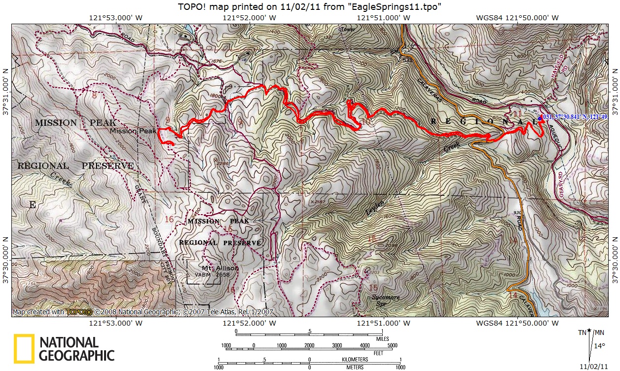
Red line shows the section
of the Ohlone Wilderness Trail we hiked in 2011 (I didn't run the gps
on this trip, but the trail is the same). Round trip elevation profile
below map. Click on map or profile for larger version.
.
(back to top)