


![]()
Page 1
 I
decided to go on this backpacking trip by myself. I left at around 8:00
from the Sunol trailhead which is at the far end of the parking lot.
This was going to be around a 20 mile one way trip so I had arranged
to be dropped off and picked up the following day at Del Valle. Maggie's
Half Acre is the closest camp near the halfway point and is a nice spot
to camp under the summit of Mt Rose. There are a lot of ups and downs
on both days of travel so make sure you are ready for that before you
tackle this trip.
I
decided to go on this backpacking trip by myself. I left at around 8:00
from the Sunol trailhead which is at the far end of the parking lot.
This was going to be around a 20 mile one way trip so I had arranged
to be dropped off and picked up the following day at Del Valle. Maggie's
Half Acre is the closest camp near the halfway point and is a nice spot
to camp under the summit of Mt Rose. There are a lot of ups and downs
on both days of travel so make sure you are ready for that before you
tackle this trip.
 The
trail is a little hard to show as the map gives some good detail and
it is 20 miles worth of trail on the Ohlone Wilderness Trail. I divided
the map into 3 sections so you get some idea of what the course looks
like. This first picture is of the trail to the Backpackers Camp area.
The blue line is the course I took through this part and then onto the
red line off this map and onto the next.
The
trail is a little hard to show as the map gives some good detail and
it is 20 miles worth of trail on the Ohlone Wilderness Trail. I divided
the map into 3 sections so you get some idea of what the course looks
like. This first picture is of the trail to the Backpackers Camp area.
The blue line is the course I took through this part and then onto the
red line off this map and onto the next.
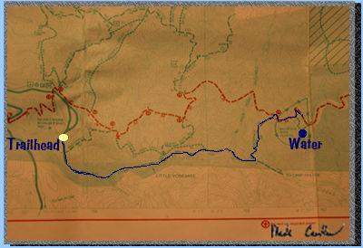
 This
picture shows the next 7 miles of trail to Maggie's Half Acre. If you
look on the right of the map you will see the trail split and then come
back together again. Maggie's Half Acre is the little yellow dot. It
sits at almost 3600 feet and you start at around 400 feet. (Yes, up
is the general direction you go.) I stayed on the red line until the
junction for Maggie's Half Acre and then on the green line to my site.
This
picture shows the next 7 miles of trail to Maggie's Half Acre. If you
look on the right of the map you will see the trail split and then come
back together again. Maggie's Half Acre is the little yellow dot. It
sits at almost 3600 feet and you start at around 400 feet. (Yes, up
is the general direction you go.) I stayed on the red line until the
junction for Maggie's Half Acre and then on the green line to my site.
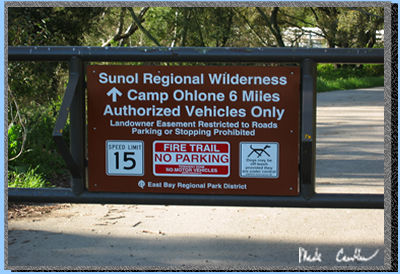
 This
is the sign you see after you get off the road and make your way to
the left up the hill to the backpacking camping area in Sunol. Once
you get up to the ridge above the backpacking area you enter Ohlone
Wilderness and you do need a permit. You can obtain your permit at the
ranger station in Sunol. (Your permit is also your map and is valid
for 1 year for 1 buck.)
This
is the sign you see after you get off the road and make your way to
the left up the hill to the backpacking camping area in Sunol. Once
you get up to the ridge above the backpacking area you enter Ohlone
Wilderness and you do need a permit. You can obtain your permit at the
ranger station in Sunol. (Your permit is also your map and is valid
for 1 year for 1 buck.)
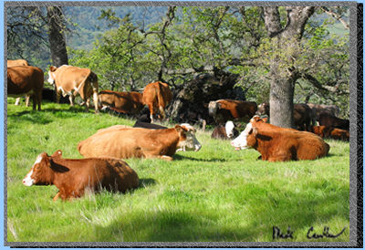 There
are plenty of cows to encounter. Most of them friendly. Do be careful
not to sneak up on a mother cow with calf. They don't like that.
There
are plenty of cows to encounter. Most of them friendly. Do be careful
not to sneak up on a mother cow with calf. They don't like that.
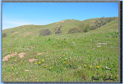
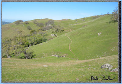 There
are plenty of wide open spaces on this trip. It is amazing to think
that Pleasanton, Livermore and Fremont are all around such a beautiful
open space. This picture is looking back towards the ridge above the
backpacking camping area of Sunol. You can see the trail as it winds
over the hills.
There
are plenty of wide open spaces on this trip. It is amazing to think
that Pleasanton, Livermore and Fremont are all around such a beautiful
open space. This picture is looking back towards the ridge above the
backpacking camping area of Sunol. You can see the trail as it winds
over the hills.
 It
was nice to have everything green and blooming. It was a little hot
but the slight breeze made it bearable.
It
was nice to have everything green and blooming. It was a little hot
but the slight breeze made it bearable.
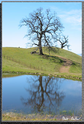
There are a few spots that I always take a picture at and this is one of them. This tree with the pond in front seems to always beg to have a picture taken.
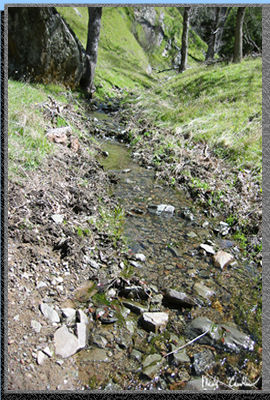 The
trail is really well marked and the map is accurate. It is not a bad
trail but does use a lot of fire roads that are often on the steep side.
You know you are getting close to the halfway point when you cross this
stream. You have to lose some elevation fast and then make it back up
the other side.
The
trail is really well marked and the map is accurate. It is not a bad
trail but does use a lot of fire roads that are often on the steep side.
You know you are getting close to the halfway point when you cross this
stream. You have to lose some elevation fast and then make it back up
the other side.
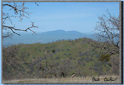 You
are really close when you see this view of Mt Diablo. You can tell how
high you are when you can look horizontally instead of up at this Bay
Area landmark.
You
are really close when you see this view of Mt Diablo. You can tell how
high you are when you can look horizontally instead of up at this Bay
Area landmark.
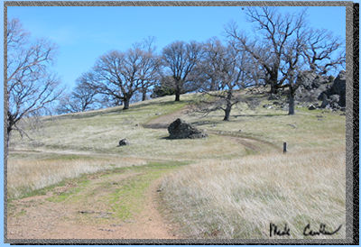 This
picture show you the junction that you take a left at to get to Maggie's
Half Acre and straight would take you up to Mt Rose (Rose Peak 3817).
I took a left here and made it over to camp. I got to camp about noon.
This
picture show you the junction that you take a left at to get to Maggie's
Half Acre and straight would take you up to Mt Rose (Rose Peak 3817).
I took a left here and made it over to camp. I got to camp about noon.
Go on to Page 2